The pattern is still forming, and we’re only in the first 15 days of this year’s new cycle. A couple of storm systems are beginning to show up on the maps, and these early signs often become the foundation of the repeating pattern we’ll track all year long.
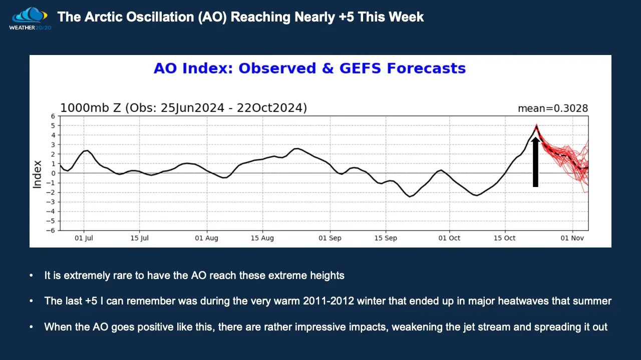
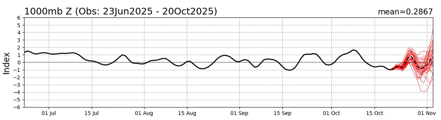
Below, we’ll compare the Arctic Oscillation (AO) Index from one year ago to today’s current setup, to see how the upper-level pattern may be influencing this early dryness.
There are four core principles of the LRC, and one of them is that a unique weather pattern sets up each fall.
This year’s pattern is already very different from any I’ve ever seen, which certainly satisfies the word unique. The atmosphere’s larger influences are also shifting in ways that set this year apart.
For example, one year ago the Arctic Oscillation (AO) was trending strongly positive, while this year it’s hovering near neutral—a completely different setup in the upper-level flow that will have ripple effects across the Northern Hemisphere.
So, the influences are different, the developing pattern is unique, and we still have a few more weeks to watch this evolve before the new LRC fully locks in.
The implications for your business and personal plans in the months ahead will be significant, and our goal is to continue providing you with the most advanced long-range weather insights and data available anywhere in the world today.
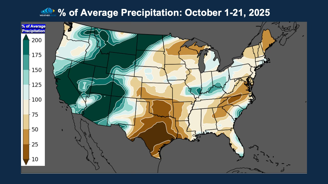
Rainfall Over the Past 21 Days
Here’s a look at the rainfall distribution across the United States over the past three weeks, highlighting the emerging wet and dry zones within the early stages of this new pattern:
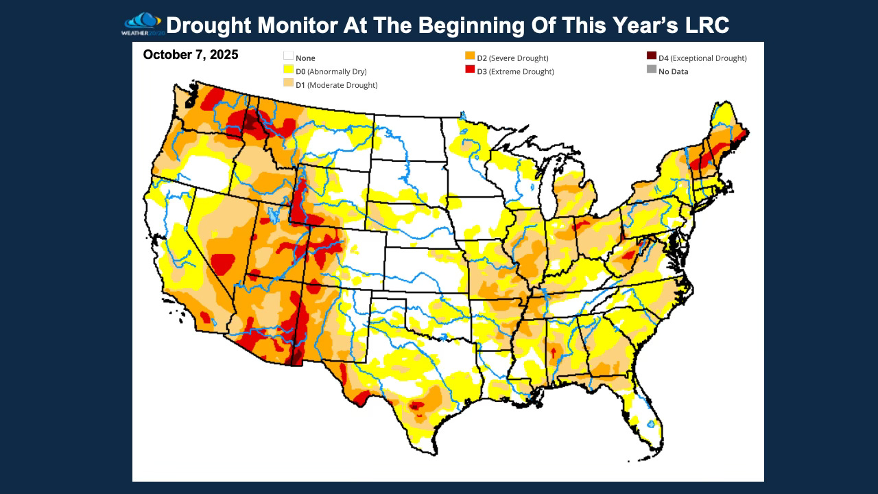
Early October Rainfall & Drought Trends
The first three weeks of October have already produced an interesting rainfall pattern, as shown above. This is something to keep in mind as we begin forming the forecast for the winter and the year ahead.
The early October Drought Monitor will be one of the key benchmarks we use to track how the new LRC evolves. Droughts are always either expanding or contracting, and their movement often provides early clues about the strength and position of key storm tracks.
Last year, we accurately predicted that drought conditions would contract across much of the Agriculture Belt, and that verified all the way through late summer. Then, by September, we began to see drought expansion once again—from Ohio back toward Missouri—in the region that struggled all of last year to have adequate rainfall. When it suddenly ended in August and September, the drought expanded.
We’ll be monitoring these trends closely over the coming weeks, and by the time we issue our full winter forecast in early December, we’ll be ready to make big, data-driven conclusions about how this new 2025–2026 LRC will shape the seasons ahead.
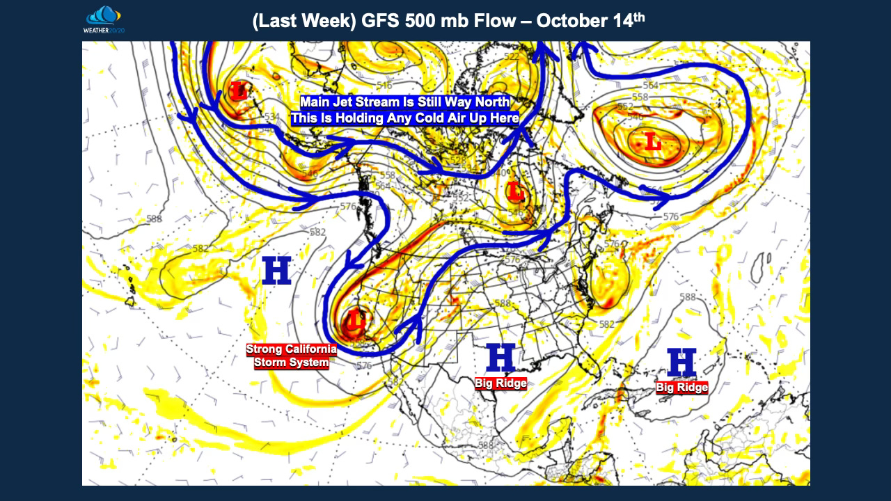
Just one week ago we had this storm coming into California. It was part of a series of storm systems that produced that big precipitation anomaly from the southwestern states up to North Dakota. This part of the pattern will return, with a big question of when? Once we learn a bit more about the LRC we will precisely predict when this will return.
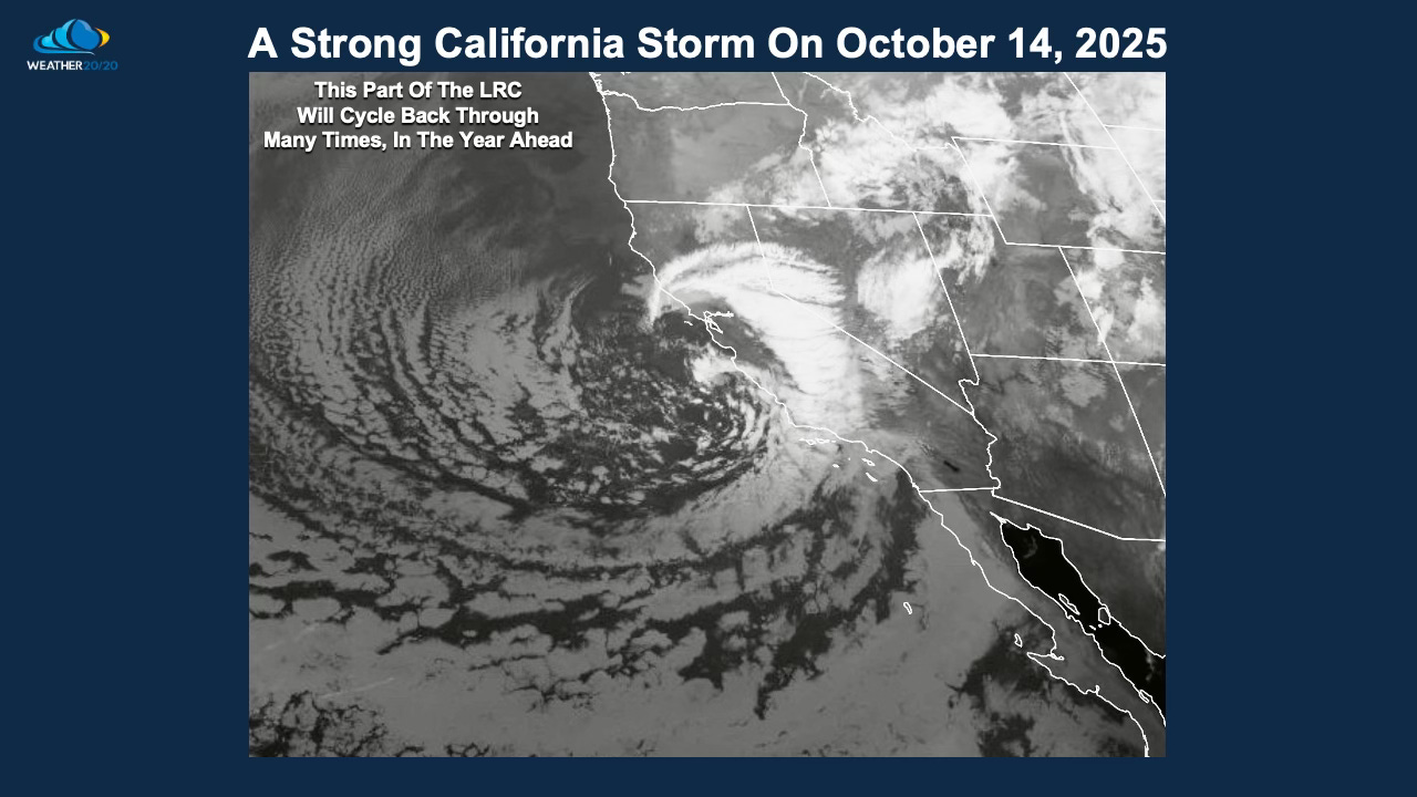
The map above highlights the California storm we’ve been tracking closely. We measure the strength of these systems using the LRC Index, which quantifies storm intensity and organization.
Here’s an interesting fact: this California storm scored higher on the LRC Index than any storm in last year’s pattern. That’s significant, because when this part of the pattern cycles back in the heart of winter, it will likely produce a powerful storm system across the western United States—one we’ll be watching very closely.
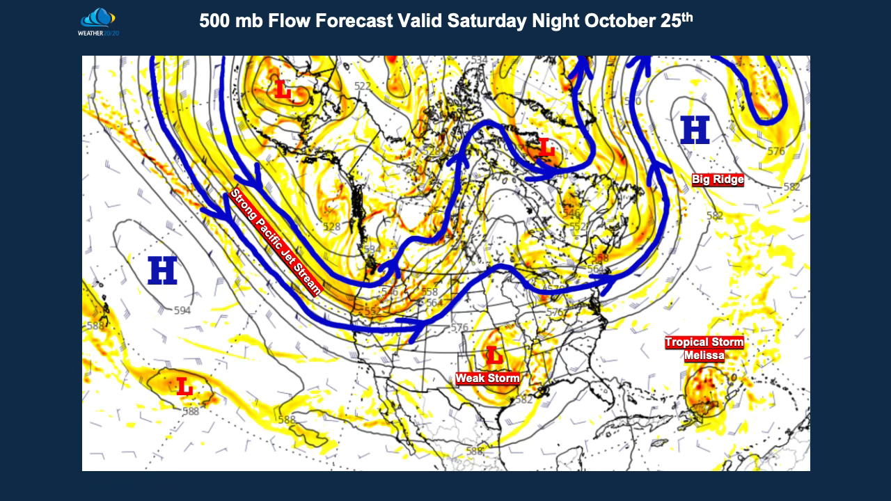
Now, let’s look at what’s happening right now. The jet stream is strengthening over the Pacific Ocean, and a lead storm system is projected to approach the Plains states between Thursday and Saturday.
This will be another key piece of the puzzle as we continue to observe how the new 2025–2026 LRC is taking shape above us.
The Next Storm System
Rain is likely to spread across parts of Oklahoma and Texas, regions that could certainly use a good soaking. Kansas and Missouri will sit on the northern edge of this lead storm, with a chance for rain bands to lift northward into the area by Friday and Saturday.
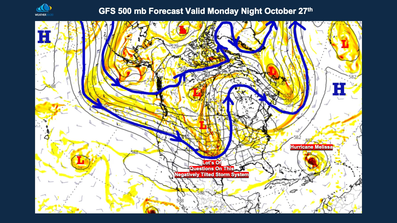
But what happens next is even more fascinating. The jet stream energy is forecast to dive southeastward, carving out a stronger storm system across the Plains.
How this next storm evolves and intensifies will tell us valuable information about the structure of the new LRC—including where the main storm tracks may set up for the winter and beyond.
So yes, a lot is on the line this week as we continue to watch the birth of the 2025–2026 cycling weather patternunfold right before our eyes.
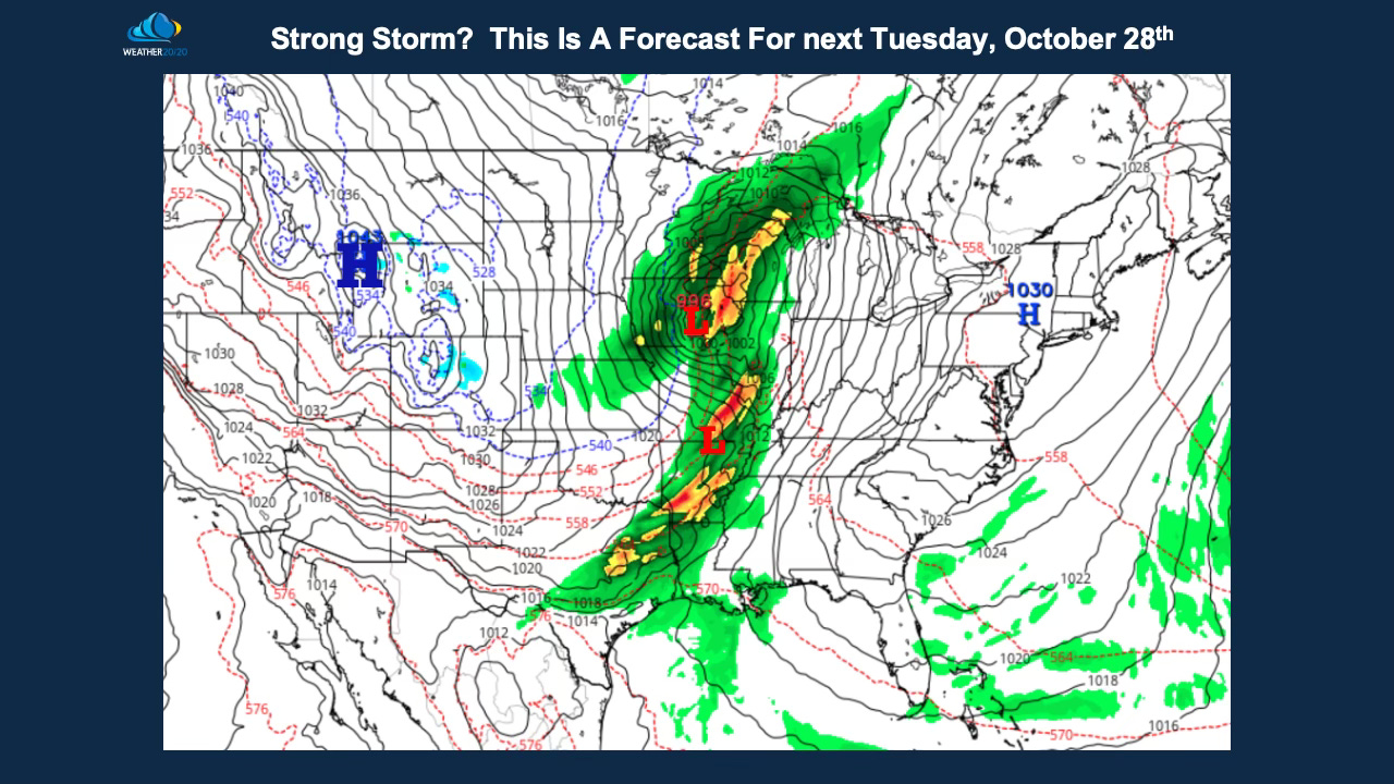
The latest data just came in as I was finishing this report, and it shows the potential for a major storm developing across the Plains, Midwest, and Great Lakes about one week from now.
The map below highlights what could become a severe weather outbreak next Tuesday. It’s still early, and there are many factors yet to be resolved—the models are offering a wide range of possible solutions.
Still, it’s an intriguing setup, and one worth watching closely as we continue to see how the new 2025–2026 cycling pattern sets up. Here is a look at just one of the possible solutions for early next week.
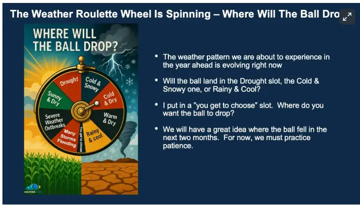
The Roulette Wheel of Weather
The roulette wheel of weather is still spinning — and right now, the ball is circling at full speed. The pattern is forming, the jet stream is realigning, and energy is transferring across the Northern Hemisphere.
In about three to four weeks, that ball will finally drop into place — and when it does, we’ll know where the new 2025–2026 LRC has truly landed.
Will it bring a stormy and snowy winter? A mild and dry setup? Or perhaps a mix of both depending on where you live?
That’s the excitement of this moment — we’re watching the atmosphere organize itself into the unique, repeating cycle that will define our weather for the next year.
For now, the key is patience and observation. Every storm, every dry spell, and every shift in the jet stream gives us another clue about the pattern’s DNA. And once the ball drops, we’ll know exactly how this new cycle will shape the seasons ahead.