


Sat, May 29th, 2021 - 11:22am
October 08, 2021 - 4:22pm | By Justin Storm
It's our second weekend of October now and as much as I wish I could tell you that we're having another beautiful weekend. That's just not going to be the case this time. But it is good news for some! We have a few scattered/isolated showers and thundershowers today. Then more widespread rain will enter the area for Saturday and pushes into Sunday.
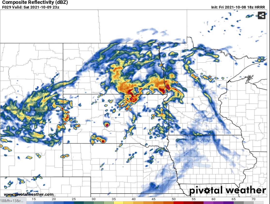
Throughout this evening will have a few isolated thundershowers stretching from the Southern valley near Fargo into northwestern MN along a slow-moving cold front. If this front stalls out or slows down more than it already has, which is possible. The chances for those isolated thundershowers would go down. (Attached below Image 1, is estimated storm coverage/reflectivity at 8:00 pm CDT, Friday night.) I'll say it's a 30% chance will get an isolated thundershower here in Fargo, Moorhead this evening.
Overnight will hand onto a 30% chance for a couple of scattered showers and/or thundershower until say 1:00 AM CDT Saturday 10-9-21. After 1:00 AM not likely to see anything but clouds until Saturday Morning along with some patchy fog. More Wider Spread rain comes into our area through the late morning into the afternoon of Saturday as low pressures enters the area.
Saturday Storms?
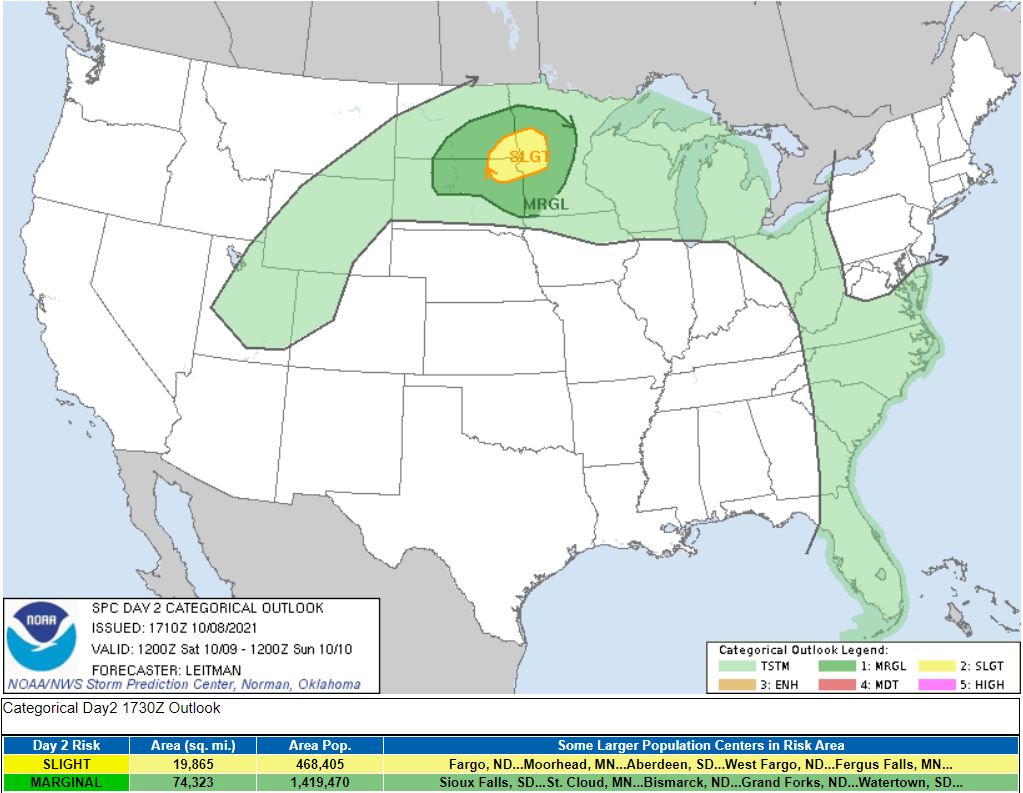
There may even be a couple of strong/severe storms come late afternoon and early evening hours of Saturday. To increase the chance of strong storms, we will need to see a little bit of sun throughout the day to help warm the surface and destabilize the atmosphere more than it already will be. However, even if we don't see much sun, with a moist boundary layer (a layer of the atmosphere near the surface), an already unstable atmosphere with steepening lapse rates ( the rate the atmosphere cools with height), and favorable wind parameters, some organized strong storms are still be expected, a couple more become severe favoring the southern valley. The main concern with these storms would first be damaging hail, then winds. Even though the tornado risk is low it can't be ruled out... just not very likely. (see image 2 below of 10/8/21 storm prediction center risk area for Saturday)
Scattered showers and thundershowers will push overnight into Sunday afternoon with on and off scattered showers across the area. The center of the low is forecasted to stall temporarily over the central/southern valley, which will calm the winds (similar to the eye of a hurricane). Showers will exit the area Sunday night. Looks like we should be able to pick up .5 - 1.0 inches of rain with higher amounts where thunderstorms track closer to 2+ (see image 3 below, estimated rainfall into Sunday.
Weekend forecast, Fargo ND
Friday night: A 30% chance for isolated thundershowers through the evening till 1:00 AM. Winds will turn from the south to the north this evening as a cool front passes around 10 mph. Expect breezier conditions near thundershowers. A low of 60 tonight with patchy fog into early Saturday morning.
Saturday: Patchy fog with wider spread rain in the afternoon. A high near 66 with easterly winds between 5-15 gusting up to 20 mph. A slight chance for a strong storm or two in the late afternoon to early evening hours.
Saturday night: Scattered showers continue overnight Sunday with winds becoming light around 5 mph. A low near 54 with patchy fog leading into Sunday morning
Sunday: A 40% chance for a few on and off leftover scattered showers through the morning and afternoon. Winds will pick up from WNW between 10-25 mph. A high near 64 with falling temperature into the 50's through the day.
Sunday night: Breezy conditions will continue with a 20% for a light shower then partially clearing skies with a low in the mid 40's.
Next Week
Next week looks more seasonable with closer to average temperatures (Average highs are close to 60 degrees). Looks like fall will finally arrive. Monday and Tuesday of next week will be nice with partly cloudy to mostly sunny skies but it will be a bit cooler than we are used to. Highs will only be in the 60's, 67 on Monday, and 62 on Tuesday. The Next chance of rain comes overnight Tuesday through Wednesday night with more widespread rain! The exact timing will change, showers could push into Thursday. Cooler more seasonable temperatures enter the area starting Wednesday through the end of the week with highs in the mid 50's to low 60's.
Extended forecast.
We're still monitoring the potential for a cool spill of air coming towards the end of October, along with another possible large-scale system. If this System, expected towards the end of October verifies it will be the third larger scaled system in October and that would be promising for our upcoming winter.
How is that, and what does that mean?
Check out this article (A Change In The Weather! How Will This Affect Our Winter? The LRC.) posted just a few days before this one on our weather tab, there you can also get your 7-Day forecast for Fargo, ND. It will explain how an active weather pattern in October will translate through the year ahead.
Meteorologist,
Justin Storm


