


Tue, Jan 4th, 2022 - 9:03am
December 27, 2021 - 10:25am | By Dean Wysocki
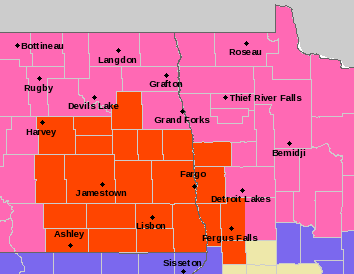
BLIZZARD WARNING UNTIL 4PM MONDAY......although snow will diminish by noon, winds blowing at times over 40mph will produce blizzard conditions through mid afternoon. TRAVEL IS NOT RECOMMENDED until winds subside this evening. Snowfall ranged from 6 to 12" thoughout much of the valley into the lakes area. 8" was common around the F/M area. We will see a SMALL break from the snow before another round enters the area from the SW Tuesday morning through afternoon depositing another 2-4" of snow. Following Tuesday's snow, ARCTIC air plunges southward. Daytime highs the rest of the week will be below zero with nighttime lows -10 to -20 with DANGEROUS wind chills around -40


