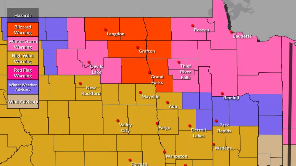
Here are the calendar outlooks for January through April using my analysis of this year’s LRC. I am trying something a little more this year in terms of seeing how accurate I can be with this year’s unique LRC. I’m adding more trends in temperatures over these four months. I will highlight when and how likely I see a cold snap or cool down, as well as a warm-up or ‘heatwave’. I’m going to hold off on exact values but expect below-average temperature of more than just a couple of degrees when you see blue, and above-average for red. Also, I will circle specific dates I find it likely or possible for a low-pressure system to bring weather and or weather impacts to our area. I’m not marking every day it may rain or snow or freezing drizzle, just the more likely dates. Many storms as has been the trend will strike north or south of us this year as the storm paths is further south, but we still have a few key dates for some possible storms. Red circles will represent a likely storm system to reemerge in our area, and yellow represents not as likely or in our area but possible. Dates may be off by a day or two as the cycles which average x amount of days, are at times oscillating at x+2 and x-2 days.
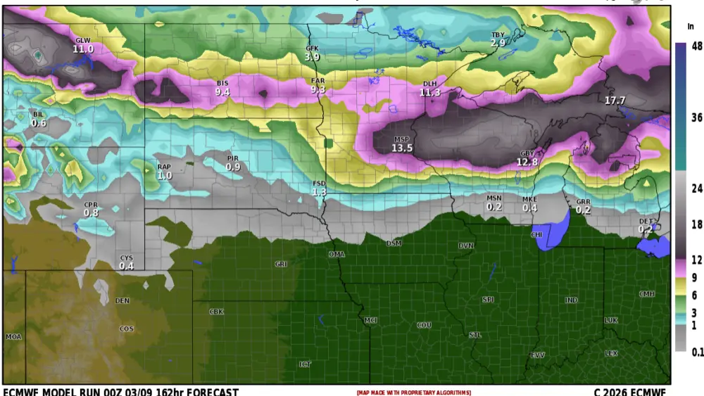
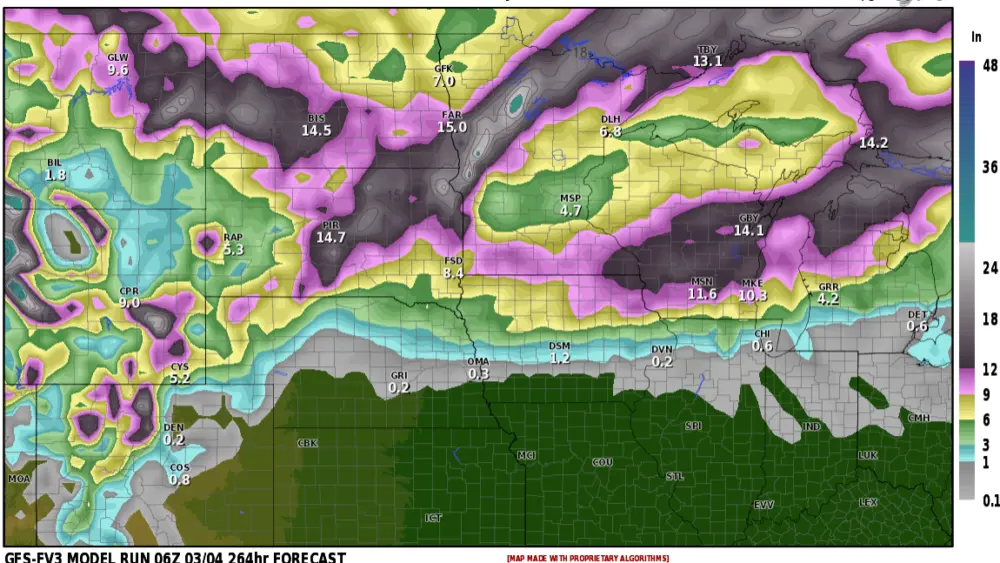
This winter into spring will likely be on a dry note, but we do have a few opportunities to build our snowpack now through March and even April with two key systems. Also outside of a couple of weeks here or there, the winter looks mild with a possible early Spring, but there is a wild card. Will talk about that later. Early indications suggest 60-110% average precipitation from December to June in our area of Eastern North Dakota and Minnesota. It looks more likely to be less than average than near or above average (70% / 30%). But all it takes is the right storm to skew those numbers in the other direction for a month.
January:
The average temperature on the 1st of January is 19 degrees, it is also 19 degrees on the 31st of January in Fargo ND. On average Fargo will acquire 10.3 inches of snow based on a 1991-2020 average. Grand Forks is similar, the average temperature at the beginning and end of the month is 16 degrees with an average snowfall of 9.5 inches.
60-110% average would be 6.2 – 11.3 inches of snow in Fargo and 5.7 – 10.5 inches in Grand Forks.
I expect a couple of clipper systems to pass through the area around the 5th and 10th followed by cold air. a couple more clippers look to pass on the 15/16th and 18/19th. The first likely missing us or at least mainly missing us, but both bring in some wind. Assuming there is some light fluffy snow on the ground could be blowing or drifting snow events. A possible impactful storm looks favorable between the 23rd and 25th, this may be deflected south of us if cold air doesn’t retreat far enough into Canada. ( In the first cycle this was the storm that brought snow just before Halloween in Central and Northeastern ND ) Another possible strong clipper will be possible at the end of the month.

February:
The average temperature on the 1st of February is 19 degrees and 28 degrees on the 29th in Fargo ND. On average Fargo will acquire 8.1 inches of snow based on a 1991-2020 average. Grand Forks is similar, the average temperature at the beginning and end of the month is 17 degrees and 26 degrees respectively, with an average snowfall of 8.2 inches.
60-110% average would be 4.9 – 8.9 inches of snow in Fargo and 4.9 – 9.0 inches in Grand Forks.
A couple of possible Alberta Clippers look possible around the 3rd, and 11th of February, with a likely clipper and or blowing snow event on or near Valentine’s Day and right at the end of the month. Three key storms cycle back this month, one around the 7/8th, and the second and third around the 18th and 24/25. These storms tracked south of our area, and will likely do so again targeting the Central Plains, but with an expected warm up in the middle of the month, one of these could track further north and they did at the beginning of the year where we got clipped in the Southern Valley and Lakes Country Minnesota.

March:
The average temperature on the 1st of March is 28 degrees and 45 degrees on the 31st in Fargo ND. On average Fargo will acquire 9.2 inches of snow based on a 1991-2020 average. Grand Forks is similar, the average temperatures at the beginning and end of the month is 26 degrees and 43 degrees respectively, with an average snowfall of 7.8 inches.
60-110% average would be 5.5 – 10.1 inches of snow in Fargo and 4.7 – 8.6 inches in Grand Forks. Of course, we will watch out for one of those big March Storms it is just more likely to keep the heavier snow totals south.
As a whole March looks mild/warm and ‘dry’ for most of the month outside of a couple of possible clippers. One around the 20th, 27th, and 30/31st. There will be a likely clipper in our area on the 14th, and a key storm to watch for the 8th-10th, followed by a brief cool down mid-month and the 23rd-24th.

April:
The average temperature on the 1st of April is 46 degrees and 62 degrees on the 30th in Fargo ND. On average Fargo will acquire 4.1 inches of snow based on a 1991-2020 average but 1.54 inches of rain and liquid equivalent snow. Grand Forks is similar, the average temperatures at the beginning and end of the month is 44 degrees and 60 degrees respectively, with an average snowfall of 3.0 inches and 1.19 inches of liquid.
60-110% average would be 2.5 – 4.5 inches of snow or .92 – 1.7 inches of liquid in Fargo, and 1.8 – 3.3 inches of snow or .71 – 1.31 inches of liquid in Grand Forks. Of course, we will watch out for one of those Spring storms with rain and ice on the warm side and snow plus wind on the backside. This will be our April wild card.
April also looks warm, possibly very warm, more on that soon. Key dates to watch for are the 3rd/4th, 14th/15th, and the 22nd to 24th. This is our wild card storm for April. It could potentially be a good rainmaker and also snow on the backside. This would likely target the northern plains for the snow chance and severe weather in the Central/Southern Plains. Areas that are more likely to see snow I would find to be western North Dakota into Central North Dakota, but it very well be too warm for snow. Following that storm, there are signs that cold air may wrap in behind bringing a brief cool down to end April. I don’t find that the likely outcome but it is a possibility given the right influences on the pattern come into play. will leave this as likely warming up and likely a rain event. (70%: 30%).

Meteorologist,
Justin Storm