The Lezak Recurring Cycle (LRC) continues to cycle above our heads regularly as we move through the fifth cycle of this year’s pattern. The LRC is named after meteorologist Gary Lezak, the founder of the LRC and Weather2020. The LRC methodology, simply put is that each fall, a new unique weather pattern sets up varying in length each year, then cycles through the year until a new pattern forms for the following fall. In most years the LRC cycle lasts between 40-60 days but can be shorter or longer. Once the pattern length is identified, one can determine what the weather pattern will be like through the following year and predict what the year’s weather will be.
The LRC is not a perfect forecasting tool but has been shown to hold a 70-80 percent accuracy in predicting weather several months in advance for an area. The LRC can be used to forecast heatwaves, cold snaps, severe weather outbreaks, hurricanes, and much more. I will focus on the probability of precipitation and storms in the Northern Plains focusing in and around the Fargo, North Dakota AREA. Although these calendars will hold credibility for around the tri-state area.
Let me explain how I’m doing this. I will highlight ‘windows’ for when I expect an upper-level wave supporting a higher probability of precipitation or storms in our area.
- Red corresponds to more likely, yellow represents less likely but possible, and or could develop out of our area.
- Dates may be off by a day or two as the cycles which average x amount of days, is at times oscillating at x+2 and x-2 days.
- I’m not highlighting every minor chance for rain.
- In some instances, there will be two or three days circled. This doesn’t mean that all three days will storm or rain.
- Within the time frame, I expect an upper-level wave to track through ‘our area’ that could support a chance of storms/rain during a portion of that day/days. Usually the first of two-day windows, and the first 2-3 days of 3-4 day windows.
- Some instances may result in most of the day being dry and decent but then a passing warm/cold front pushes through and we get some storms that develop along it, or perhaps an overnight event.
- Due to influences that act on the LRC pattern, a couple of these systems may ‘wobble’ and push further north, south, east… etc. Or be a day or so off due to the pattern oscillation period.
I’m introducing something new to these calendars and trying my best to predict the types of precipitation here so be patient with me if some of these are “off”. I will be using the following graphics.
- A cloud with rain and no sun(like on May 2) = a widespread rain chance
- Rain showers with a sun ( like May 3) = scattered rain showers in the area chance
- A thunderstorm (like on May 6) = scattered storms and rain chance
- A thunderstorm with wind (like on May 26) = possible severe storms or risk
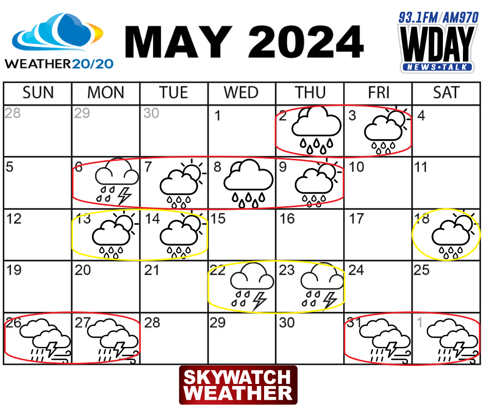
Welcome to May. I’ve highlighted a few windows through May. The first is at the beginning of the month, with a likely chance for widespread rains turning into scattered showers on the second and third. The second week of May, this feature is one of the signature storms of this year’s LRC, think back to around Christmas… do you remember? This will likely be a larger-scale storm system that is expected to “park” over the area and bring a likely chance for on and off rains for a few days. Not to say that it is going to rain straight for four days, but those four days will be the best shot of seeing rain in the area. The next area to keep an eye on would be the 13 and or 14th with a scattered showers chance as well as the 18th of May. To end the month of May I’ve highlighted the 22 and the 23rd as a window to a heightened chance for some scattered storms in the area. I’ve left this as a yellow circle only because I think this threat is going to remain just south of us. However, it could bring us our first severe weather threat if it lift further north than I expected. On the 26/27th and 30/1st of June, I expect two upper-level waves to pass across the Central and Northern Plains that would tighten the chances for severe weather or scattered storms. This portion of the cycle has produced severe weather threats in the past cycles and will likely produce another.
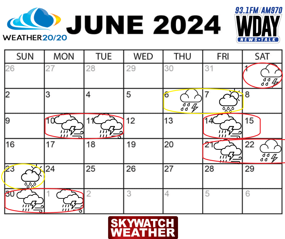
Turning the page into June the next window comes on the 6th and or 7th with a chance for some storms on likely one of those days as well as a likely chance for severe weather mainly just south through the Central Plains extending into South Dakota, this will be something to keep an eye on for us here in ND. The 10/11th and 14/15th are two more likely windows to see the chance a portion of those days. This portion of the Cycle was responsible for an outbreak of severe weather to the south in the Southern and Central Plains. After that things should quiet down until another signature storm comes through likely between the 21st and 23rd. Finally one more chance for storms or severe weather risk at the end of the month.
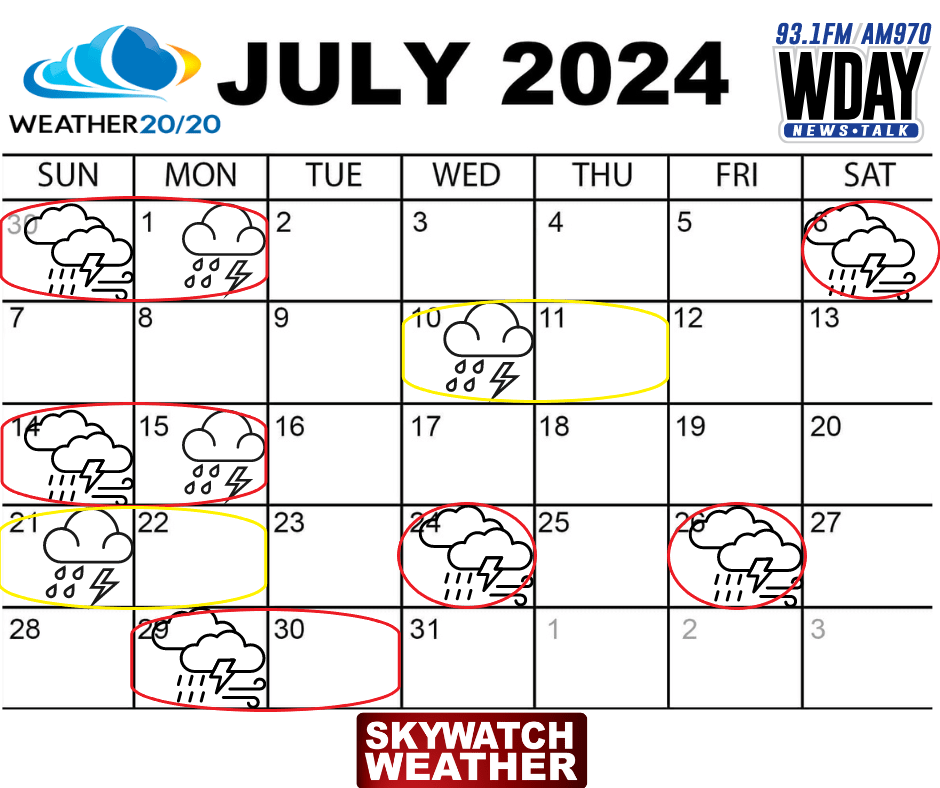
July contains fewer threat windows, but there will be some dates in here where I feel we could see some severe weather risks, or at least in our area within the Northern Plains. Those dates contain around the 6th, 14th, 24th, 26th, and 29/30th. The end of the month (21st through the 30th) again contains a portion of the cycle that could produce a similar setup to cycles past that produced several days of severe weather risks and outbreaks to our south.
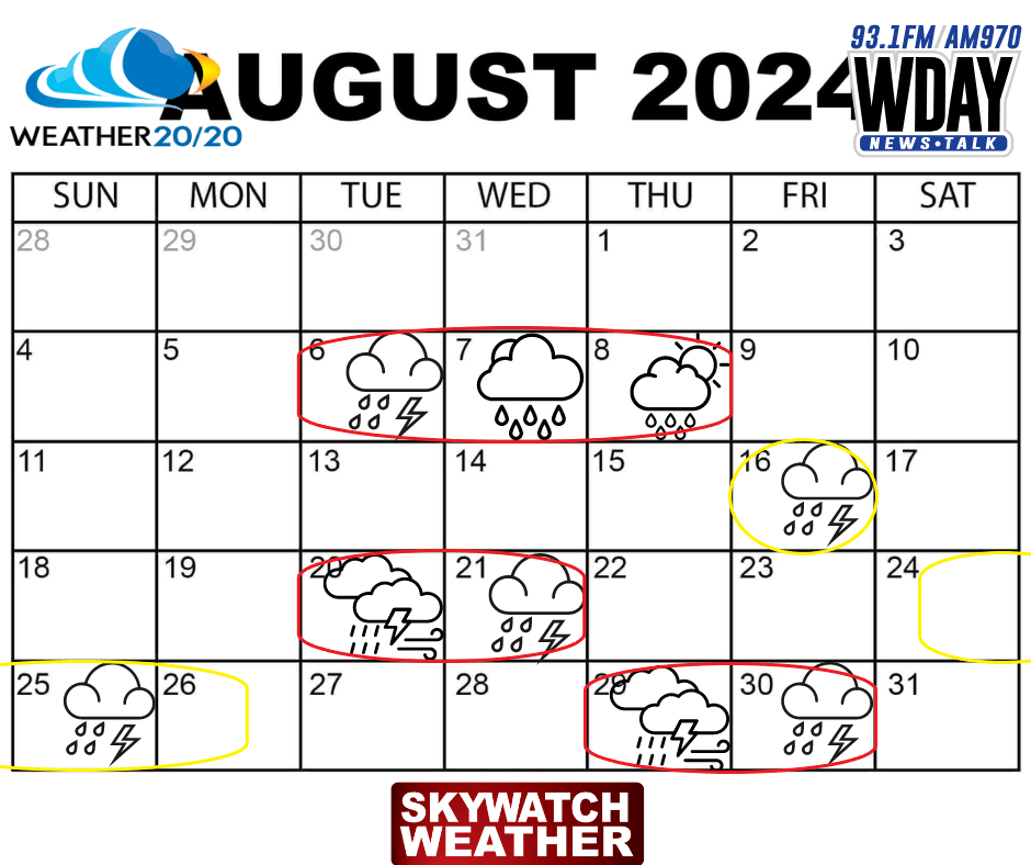
For the most part severe weather should wind down in August but still possible. The main threats for rain and storms come between the 6th and 8th, and the 20th through the end of the month.
Let me know If you have any questions, you can email me at weather@flagfamily.com.
-Meteorologist Justin Storm