It’s been a pretty decent week around the area but we are about to go into one of the “stormier” phases of the LRC, here’s how it looks:
Welcome To The Weather 20/20 Intelligence Report!
To our premium subscribers—welcome back. You’re already ahead of the curve. And if you’re new here or considering upgrading, this is your gateway to a forecasting method that doesn’t guess—it knows, weeks to months in advance.
Over the past 30 days, much of the central U.S. has benefited from well-timed, meaningful rainfall. Key agricultural zones have seen moisture return just when needed most. But not every region is on the winning side of this cycle—pockets of persistent dryness remain, particularly across parts of Missouri, where the pattern has also been consistent, consistently missing with heavy rainfall, and yet still perhaps getting just enough.
These rainfall patterns are not random. As we’ve tracked since October, the current LRC cycle—now repeating for the 6th time—has returned key systems on schedule, bringing precipitation to many of the same regions that benefited in prior cycles, or even have had too much rain over parts of southern Missouri, Oklahoma, and Arkansas.
As we’ve seen time and time again this year, the LRC doesn’t just bring storms on schedule—it brings them back to the same regions, again and again.
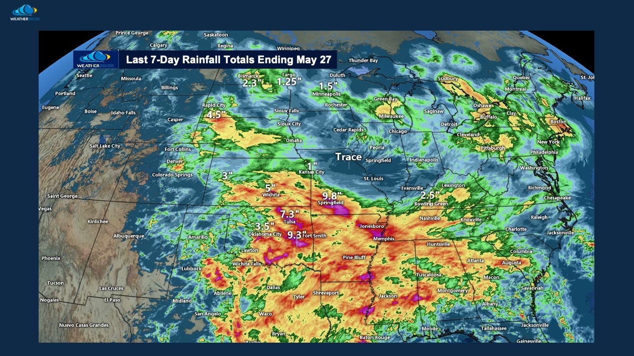
Certain zones—especially across parts of Oklahoma, southern Missouri, and the Mid-South—continue to get hit with round after round of rain. Meanwhile, just a few counties away, it’s been a frustrating weather pattern to experience with so many near misses and lingering dryness. This sharp gradient is no accident. It’s the fingerprint of a powerful, structured pattern at work. It is personally driving my weather mind a bit crazy, even though I know it is this year’s LRC causing it.
But there’s some good news.
Cooler air filtering in has helped slow evaporation, and more importantly, we’ve now entered the stormier and wetter phase of the cycle that lasts three weeks, the “phase 1” of this year’s LRC as we have discussed so often. Based on the timing and energy in this latest return of the LRC, we’re confident that new opportunities for soaking rainfall are emerging, especially in some of the regions that have been left out in previous cycles. Now, I have said this before, and then the rainfall patterns have fallen right into the same spots.
Before summer locks in, we’re tracking multiple storm systems with the potential to deliver meaningful rain to those drier pockets.
Take a look at the past two 30-day rainfall charts below. They’ll give you some perspective on who’s been hit hardest—and who’s still waiting.
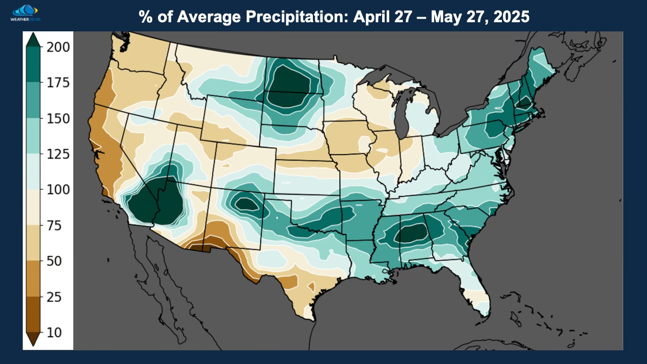
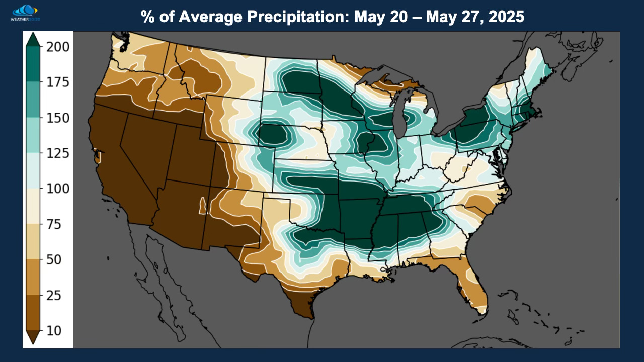
Over the past month there has been an overall drier region from along the Kansas/Nebraska border extending and expanding northeast over Iowa, northern Missouri, Illinois, into Indiana. On the second map, that drier zone has been shrinking. Now look at the forecast from the Euro AI and the GFS (American Model):
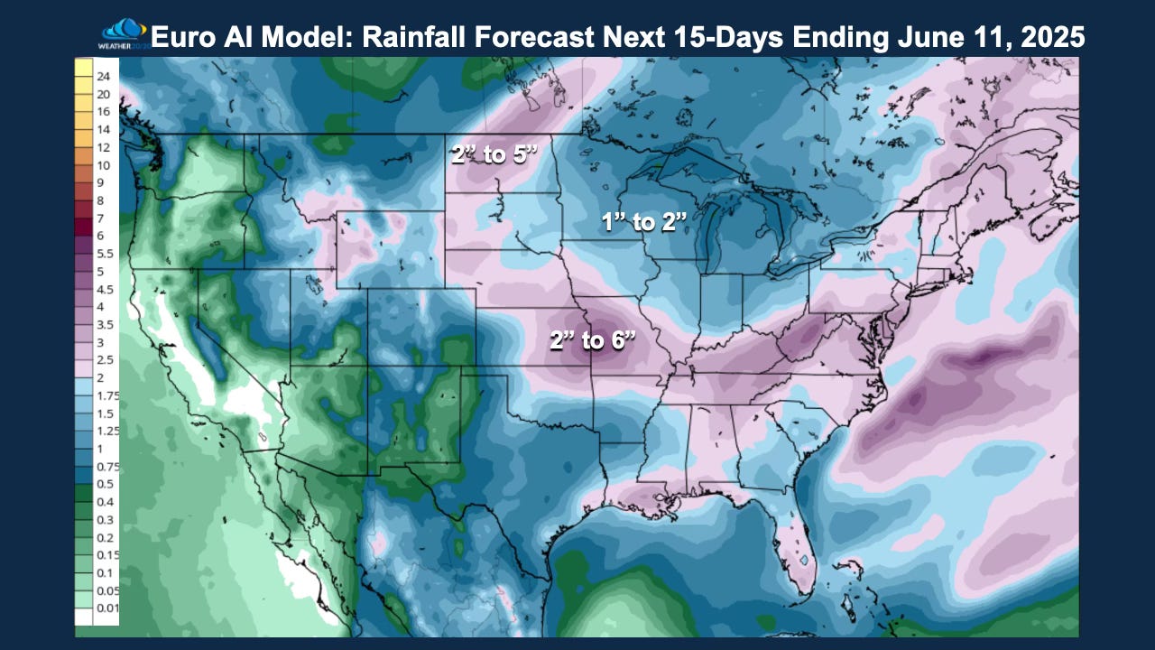
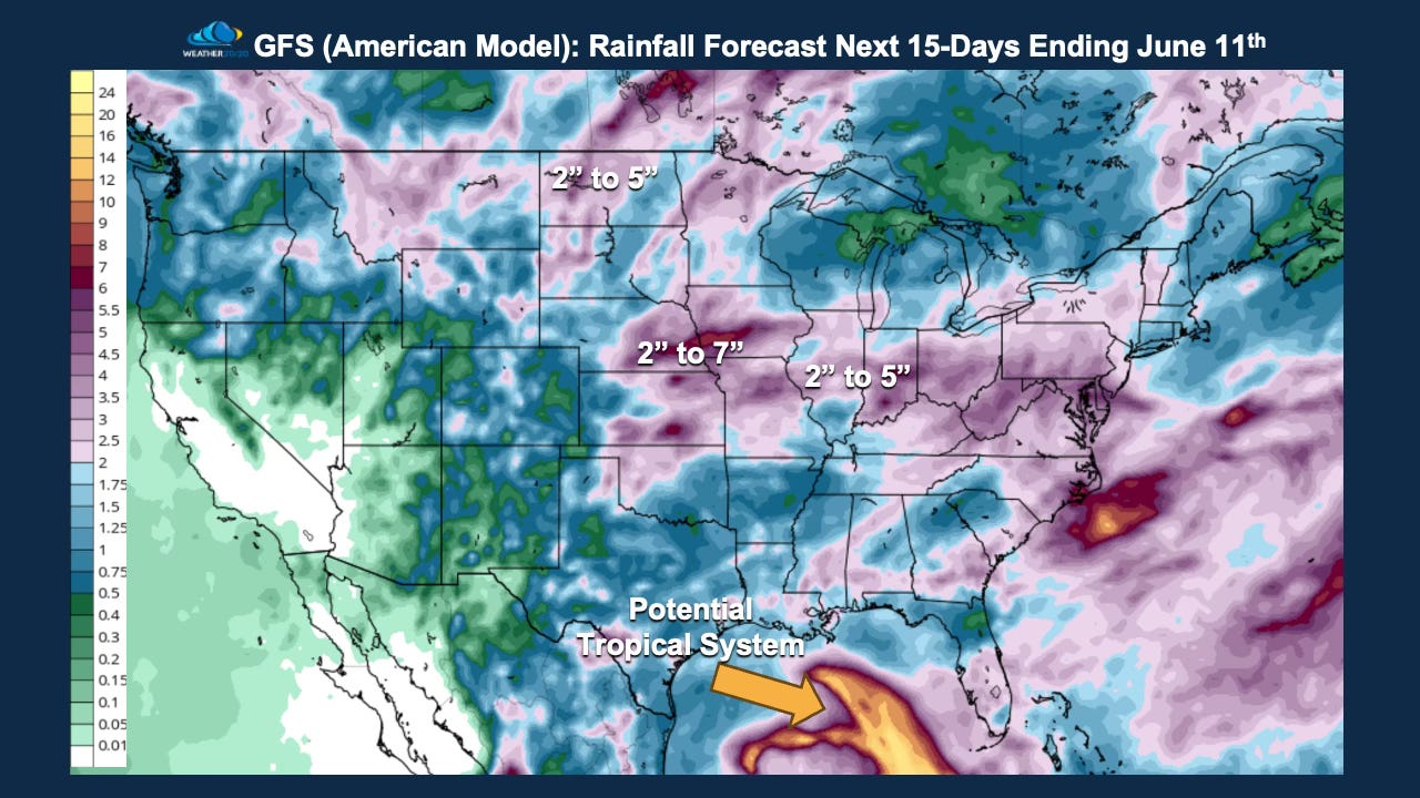
Both the GFS and ECMWF AI models are now showing widespread rainfall totals of 2 inches or more across several of the drier regions we’ve been watching closely. This is exactly what we expected from the stormier, wetter phase of the LRC, and it’s arriving right on schedule.
With these incoming systems, severe weather risks and localized flooding will be part of the forecast over the next two weeks, as the pattern continues to cycle with precision.
But look a little farther south.
Take a closer look at the Gulf of Mexico. That swirling feature you’re seeing may look like a giant sea creature, but it’s actually something more familiar—and potentially more impactful: potentially a developing tropical system.
We’ve been watching this window closely, and it may end up being the first named storm of the 2025 hurricane season. Now, it isn’t showing up on any satellite picture yet, so let’s just monitor it closely. It just happens to fit our forecast of a system related to Hurricane Rafael back in November.
Just yesterday, we released our 2025 Hurricane Season Preview, which outlines five high-impact windows for tropical development based on the LRC. If you haven’t seen it yet, here is the Youtube link: 2025 Hurricane Season Preview
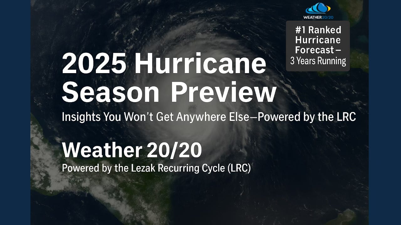
In our 2025 Hurricane Season Preview, we spotlighted three key LRC segments that are likely to produce named tropical storms or hurricanes this season. These aren’t vague trends—each one is tied directly to a prior weather “seed” that formed during the fall setup of this year’s pattern.
Based on the cycle timing and returning atmospheric energy, we highlighted the June 5th to 10th window, give or take a couple days, as a period to watch for possible tropical development in the Gulf.
If this develops further, it could become the season’s first named storm, kicking off a hurricane season we’ve already forecasted in detail. This part of the pattern will cycle through two more times as we get deeper into hurricane season.
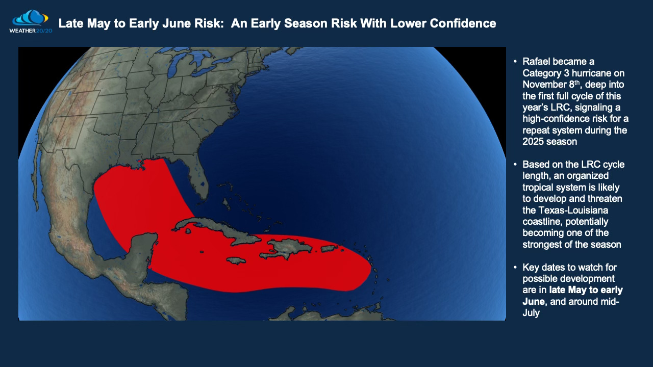
Let’s see if this region produces an organized system in the next two weeks. If a named storm does form early—right where and when we anticipated—it significantly raises the probability that this area will see an even stronger system later in the season, during the next return of this pattern segment, or more likely in mid-late August in the 8th cycle of this year’s pattern.
And this is exactly where Weather 20/20 sets itself apart.
While other forecasters continue to issue vague, once-a-season outlooks—offering little more than a count of storms—we go deeper. With the LRC, we’re not just asking how many. We’re answering when, where, and why.
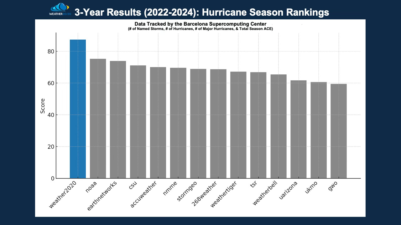
That’s the power of the LRC—and the reason we’ve been ranked the #1 hurricane season forecaster three years in a row, based on independent data from the Barcelona Supercomputing Center.
Just today, I read yet another article suggesting a “quiet” hurricane season ahead.
Let me be clear:
That’s not what we’re seeing.
And if you’ve followed those traditional forecasts the last few years… you already know how that’s gone.
We’ve been right when others have been wrong—because we’re not guessing.
We’re tracking the cycling pattern of the atmosphere.
We’ve cracked the code.
That’s how.
The LRC.
As the next two weeks unfold, we’ll be watching closely to see if the Gulf delivers the first named storm of the season. These early season tropical systems often struggle, so let’s see if anything does begin to organize.
At Weather 20/20, we don’t just issue seasonal numbers—we deliver location-specific, time-targeted forecasts rooted in decades of atmospheric pattern recognition. And, this is what we also do for your week-by-week, day-by-day analysis on the Weather 20/20 Vision dashboard.
If you want to know where and when the biggest threats of the 2025 hurricane season are likely to strike, and why we believe several landfalls are coming, it’s all in the guide.
Visit Weather2020.com now to get access to the full 2025 Hurricane Season Forecast Guide, including:
- Our 5 high-risk windows for named storms and hurricanes
- Landfall threat zones
- Seasonal outlook analysis
- Updates through the peak of the season