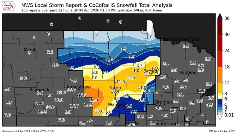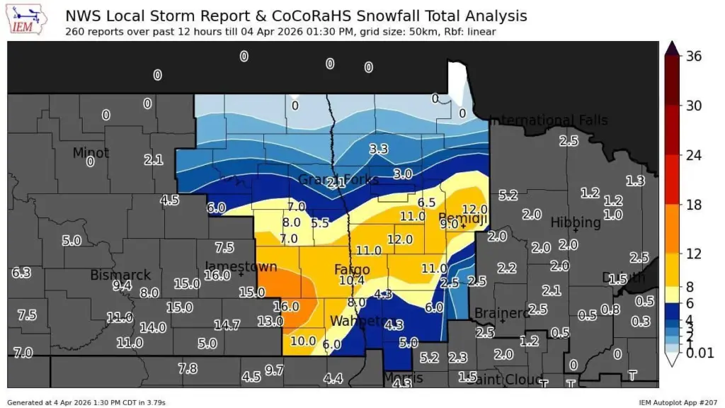
It was a storm to remember. Fargo set a daily record for snowfall and much of the area saw the biggest snow since March of ’23. Here’s a look at some snowfall totals from the 2 storms combined:
...REPORTED STORM TOTAL SNOW FROM BETWEEN 7AM APRIL 4 TO
 7AM APRIL 5 2026....

These reports have been vetted by NWS Grand Forks as representative
of event total amounts after snow stopped. Other reports have been
received within the heavy snow event, some of which produced higher
amounts. However, these reports were not included within this statement
because snow was still ongoing. A complete list of local storm reports
of snowfall can be found in other summary documents.

Reports sorted by highest to lowest reported amount.

Location                     Amount    Time/Date       Provider
Tenstrike 9.0 NW             15.0 in   0700 AM 04/05   COCORAHS
Fargo ND 6.3 S               14.5 in   0700 AM 04/05   COCORAHS
3 SSW Fargo                  13.5 in   0414 PM 04/04   Public
West Fargo 2.1 SSW           13.0 in   0700 AM 04/05   COCORAHS
4 N Muskoda                  12.8 in   0629 PM 04/04   Public
Moorhead MN 6.1 NNW          12.8 in   0700 AM 04/05   COCORAHS
Hawley MN 5.2 WNW            12.8 in   0700 AM 04/05   COCORAHS
7 SW Barrie                  12.0 in   0950 PM 04/04   Public
Audubon                      12.0 in   0951 PM 04/04   Public
Rollag 4.6 S                 11.9 in   0700 AM 04/05   COCORAHS
Lake Park MN 9.9 S           11.7 in   0700 AM 04/05   COCORAHS
Solway MN 2.1 S              11.2 in   0800 AM 04/05   COCORAHS
Mcleod ND 3 E                10.2 in   0925 AM 04/05   COOP
Shelly MN 0.2 SW             10.0 in   0800 AM 04/05   COCORAHS
Lake Park MN 6.0 S           9.5 in    0700 AM 04/05   COCORAHS
Dilworth                     9.0 in    0951 PM 04/04   Public
2 NNW Dunvilla               9.0 in    0951 PM 04/04   Public
Erksine MN 7.6 SSW           9.0 in    0800 AM 04/05   COCORAHS
Grandin ND 7.1 ENE           8.8 in    0700 AM 04/05   COCORAHS
Ogema                        8.5 in    0953 PM 04/04   Public
Bemidji MN 7.8 ENE           8.1 in    0700 AM 04/05   COCORAHS
Ottertail MN                 8.0 in    0851 AM 04/05   COOP
Abercrombie ND 0.2 NW        7.5 in    0600 AM 04/05   COCORAHS
Cooperstown ND 0.4 WNW       7.1 in    0630 AM 04/05   COCORAHS
Rothsay MN 9.1 WNW           7.0 in    0800 AM 04/05   COCORAHS
Goodridge MN 7.4 SW          6.8 in    0700 AM 04/05   COCORAHS
New York Mills MN            6.0 in    0820 AM 04/05   COOP
Larimore ND 0.4 SE           5.8 in    0700 AM 04/05   COCORAHS
Mayville ND                  5.5 in    0700 AM 04/05   COOP
Woodland Park MN 2.1 W       5.5 in    0700 AM 04/05   COCORAHS
Wadena MN 1.0 NE             4.9 in    0700 AM 04/05   COCORAHS
Park Rapids MN 1.0 NNE       4.7 in    0700 AM 04/05   COCORAHS
Laporte MN 8.0 NNW           4.5 in    0515 AM 04/05   COCORAHS
East Grand Forks MN 4.9 N    4.5 in    0700 AM 04/05   COCORAHS
Fergus Falls MN 5.6 NNE      4.4 in    0700 AM 04/05   COCORAHS
Park Rapids MN 2.0 NNW       4.0 in    0700 AM 04/05   COCORAHS
Wadena 0.3 ENE               3.7 in    0800 AM 04/05   COCORAHS
Williams MN 2.9 E            3.5 in    0700 AM 04/05   COCORAHS
Menahga MN 3.1 N             3.5 in    0800 AM 04/05   COCORAHS
Hoffman MN 4.0 WSW           3.2 in    0700 AM 04/05   COCORAHS
Deer Creek MN 2.0 WSW        3.1 in    0700 AM 04/05   COCORAHS
Devils Lake 5.6 NW           3.0 in    0700 AM 04/05   COCORAHS
Oslo                         2.5 in    0953 PM 04/04   Public
Warroad MN 4 W                T in     0700 AM 04/05   COOP
Warroad MN 1.8 WNW            T in     0700 AM 04/05   COCORAHS


Some pretty impressive totals stretching from Jamestown through Fargo.  Now, we look forward to melting this snow and by next weekend, take a look at  the projected temps:
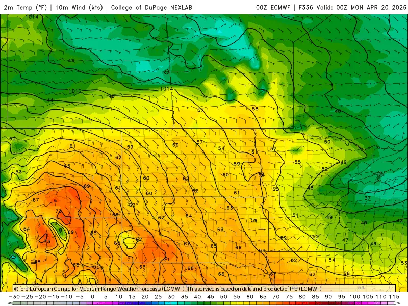
Temps near 60 across much of the state on Sunday. Showers and a few THUNDERSHOWERS for next week….BUT…I’m still a bit concerned for the 14-17th of April as a bigger storm is likely in the northern/central plains…..stay tuned.