The storm that hit last Friday night is one of a lifetime for sure. Here is a look at the 17 tornadoes that struck the state:
| 0140 | 4 WSW Spiritwood | Stutsman | ND | 4691 | 9857 | Initial touchdown. (BIS) | |
| 0140 | 6 NW New Salem | Morton | ND | 4692 | 10149 | Photo of tornado from public matches up with reports of sightings from New Salem area … and corroborated with radar data. No damage reported. (BIS) | |
| 0150 | 2 ENE Spiritwood | Stutsman | ND | 4694 | 9846 | (BIS) | |
| 0200 | Urbana | Barnes | ND | 4693 | 9841 | Numerous homes were reported damaged north of Urbana and west of Eckelson. Time estimated by radar. (FGF) | |
| 0200 | 3 NW Eckelson | Barnes | ND | 4696 | 9837 | Large … partially rain-wrapped tornado reported 3 miles NW of Eckelson. (FGF) | |
| 0210 | 5 WNW Adrian | LaMoure | ND | 4663 | 9864 | Brief tornado touched down near Stutsman and LaMoure County line. NDAWN Marion station webcam had visible funnel cloud around this time … and public submitted video of (BIS) | |
| 0214 | 1 N Urbana | Barnes | ND | 4695 | 9842 | house damaged by tornado … reported by a storm chaser. (FGF) | |
| 0221 | 2 S Sanborn | Barnes | ND | 4691 | 9823 | A tornado was reported just SW of the Sandborn exit. (FGF) | |
| 0225 | 2 S Sanborn | Barnes | ND | 4691 | 9822 | A funnel cloud was observed just south of Sandborn. (FGF) | |
| 0258 | 2 W Valley City | Barnes | ND | 4692 | 9805 | A tornado was reported 2 miles west of Valley City. (FGF) | |
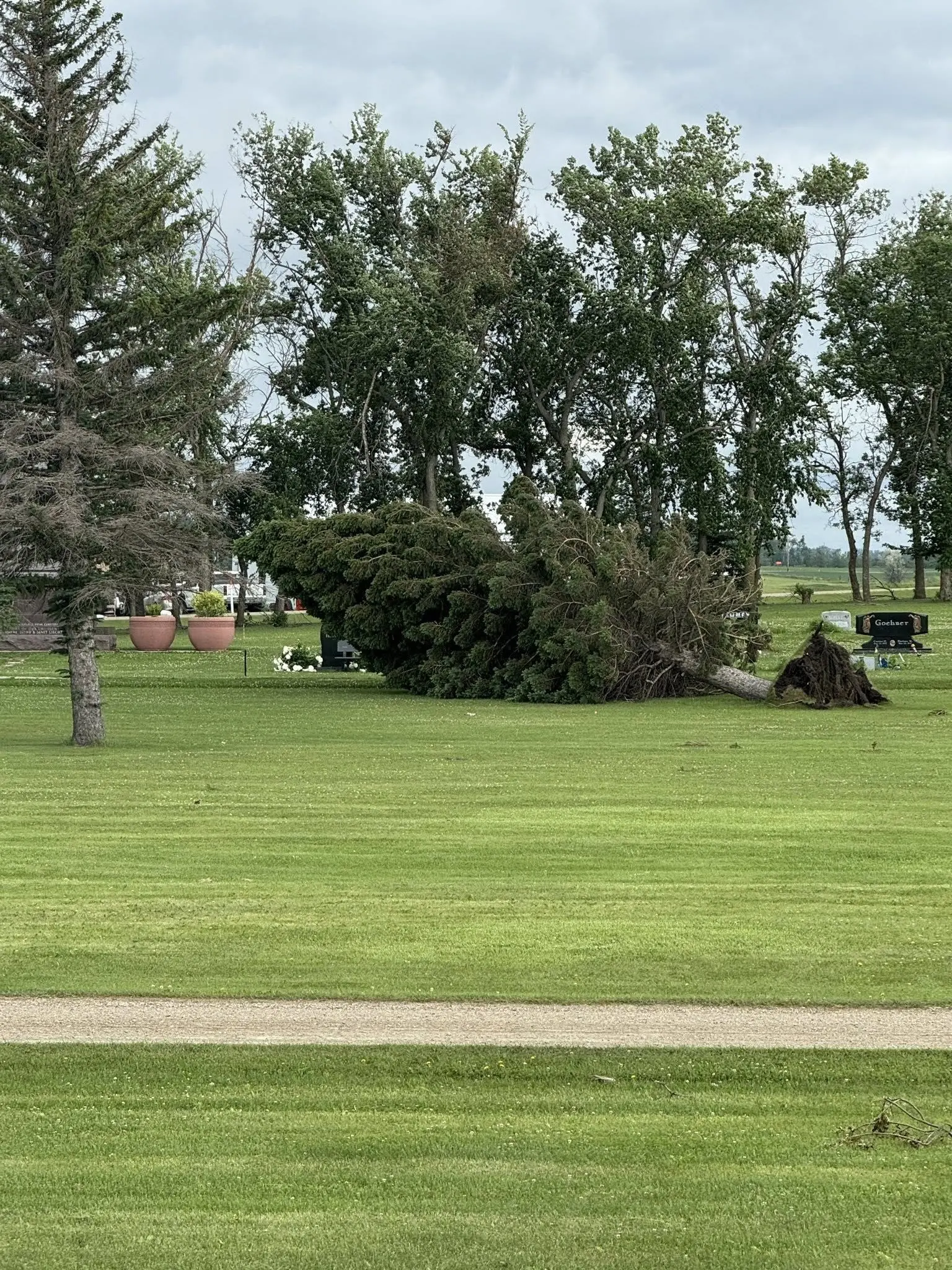
| 0309 | 4 NE Crystal Springs | Stutsman | ND | 4693 | 9941 | QLCS tornado damage reported via social media. Trees snapped down to the trunk with leaves and branches blown off. Power towers bent and twisted. Roof damage to one far (BIS) | |
| 0310 | 12 N Verona | LaMoure | ND | 4653 | 9810 | Social media report and pictures of a brief tornado north of Verona and west of Highway 1. (BIS) | |
| 0330 | 1 N Fort Ransom | Ransom | ND | 4654 | 9793 | Stovepipe tornado reported N of Fort Ransom via public. (FGF) | |
| 0411 | 3 E Enderlin | Ransom | ND | 4662 | 9754 | Damage to multiple homes were reported 3 miles east of Enderlin. (FGF) | |
| 0411 | 3 E Enderlin | Cass | ND | 4663 | 9753 | There were reports of home damage east/northeast of Enderlin. Time estimated via radar. (FGF) | |
| 0420 | 5 E Sheldon | Ransom | ND | 4657 | 9738 | A tornado was reported southeast of Enderlin. Location estimated via radar. (FGF) | |
| 0450 | Davenport | Cass | ND | 4671 | 9707 | Delayed report: A funnel cloud was reported in Davenport with possible touchdown. (FGF) |
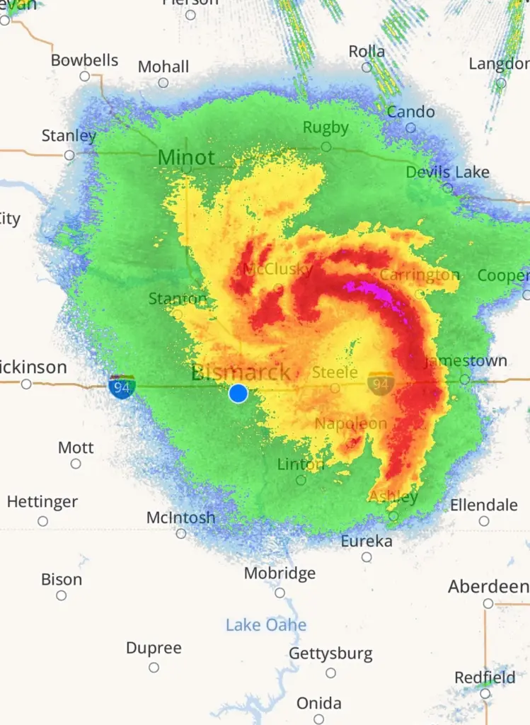
Storms rolled out of Western ND and really ramped up around Jamestown doing quite a bit of wind damage:

As the storms moved east of Jamestown, they became tornadic and here is a rundown of the Enderlin tornadoes:
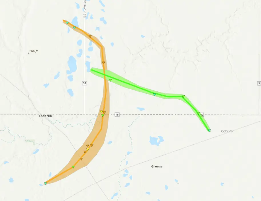
...NWS Damage Survey for 6/20/2025 Enderlin Tornadoes...

.Overview...

It is important to note these results are preliminary and subject to
change pending further evaluation. NWS damage survey results take
into account damage intensity for scientifically proven damage
indicators. If and when more damage evidence is available,
further evaluation of the damage intensity will be investigated.

The Enderlin tornadoes resulted from a supercell thunderstorm that
moved in from the west. This thunderstorm produced two long
tracked tornadoes.

The first tornado began 3 miles south of Enderlin and
tracked to the northeast, then north across highway 46, and
finally to the northwest where it weakened and dissipated. This
tornado was on the ground for around 12 miles, and at its widest
was about one mile wide. Damage indicators along the path of this
tornado correlates to EF-3 damage, with peak winds estimated to
be around 160 mph. EF-3 damage was noted along about 7.5 miles of
the total path.

A second tornado developed from the same supercell thunderstorm
about 4 miles northeast of Enderlin and tracked to the southeast,
crossed Highway 46, and then weakened and dissipated. This
tornado was on the ground for around 8 miles, at its widest was
about a half mile wide. Damage indicators along the path of this
tornado correlates to EF-1 damage, with peak winds estimated to be
around 110 mph.

.Enderlin Tornado #1...

Rating:                 EF3
Estimated Peak Wind:    160 mph
Path Length /statute/:  12.0 miles
Path Width /maximum/:   1760 yards/1 mile
Fatalities:             3
Injuries:               Unknown

Start Date:             06/20/2025
Start Time:             11:02 PM CDT
Start Location:         3 S Enderlin / Ransom County / ND
Start Lat/Lon:          46.5728 / -97.6031

End Date:               06/20/2025
End Time:               11:21 PM CDT
End Location:           4 SSW Alice / Cass County / ND
End Lat/Lon:            46.7076 / -97.5815

Survey Summary: The damage began as just a few branches but
within 2.5 miles of the track, the tornado gained intensity and
significantly widened. While south of Highway 46, the tornado
derailed several train cars and threw one train car approximately
300 feet. Additionally, a cell tower was blown over, crops
destroyed, and many large trees snapped with some debarked. A farm
house was leveled with many outbuildings destroyed. As the
tornado moved north of Highway 46, it caused devastating damage
to two houses, one being a farmhouse that was leveled and led to
2 fatalities. The tornado continued north, causing tree damage and
eventually leveling another farm house, leading to 1 fatality. As
the tornado moved to the northwest, it bent over tall steel
electrical transmission towers, and then eventually weakened and
dissipated.


.Enderlin Tornado #2...

Rating:                 EF1
Estimated Peak Wind:    110 mph
Path Length /statute/:  8.0 miles
Path Width /maximum/:   880 yards/0.5 mile
Fatalities:             0
Injuries:               Unknown

Start Date:             06/20/2025
Start Time:             11:22 PM CDT
Start Location:         4 NE Enderlin / Cass County / ND
Start Lat/Lon:          46.6666 / -97.5478

End Date:               06/20/2025
End Time:               11:34 PM CDT
End Location:           4 ENE Sheldon / Ransom County / ND
End Lat/Lon:            46.6159 / -97.4064

Survey Summary: Along the path of this tornado was extensive tree
damage, including trees snapped and uprooted. Several roofs were
partially blown apart as well. This tornado crossed the path of
the first tornado which is evidenced by drone footage showing
field scour marks in different directions.

&&

EF Scale: The Enhanced Fujita Scale classifies tornadoes into the
following categories:

EF0.....65 to 85 mph
EF1.....86 to 110 mph
EF2.....111 to 135 mph
EF3.....136 to 165 mph
EF4.....166 to 200 mph
EF5.....>200 mph

This is what many are saying, and I tend to agree, that this will go down as a storm of a lifetime for many.  First tornado death in the state since the 2018 Watford City tornado and first deaths in Eastern ND since the 2007 Northwood tornado.

Chief Meteorologist,
Dean Wysocki