After having a chat with weather2020.com CEO Gary Lezak about the arctic air mass on the way AND how SSW (Sudden Stratospheric Warming) may be the cause of it, Gary said to me “Woah….it’s not exactly correct. We need to discuss SSL (Sudden Stratospheric Lowering)
Here’s a brief look on what is happening or about to happen:
A shift in the weather pattern evolving in the coming days & weeks is part of the cycling weather pattern known as the Lezak Recurring Cycle (LRC). It is likely about to turn much colder, with a potential Arctic blast!
Over the past week, I’ve seen a lot of discussion on social media about a “Sudden Stratospheric Warming (SSW) event” and how it is supposedly responsible for the Arctic blast forming in the coming days. This topic resurfaces every year — and every year, I notice the same misunderstanding repeating itself.
But something different caught my eye, and I propose this concept of SSW is really SSL.
In several widely shared graphics, the diagrams intended to show “Sudden Stratospheric Warming” were placed directly above a deepening Arctic air mass in the troposphere. For years I’ve felt the interpretation was backward — and this raised a fundamental question:
👉 Is the stratosphere actually warming… or is it simply being pulled downward by what’s happening below, or actually a combination of both?
Let’s look at this through the lens of atmospheric structure — and with a bit of clear, business-minded common sense, scientific truth.
Credit: weather2020
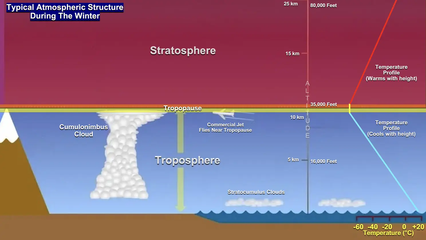
Typical atmospheric temperature profile: The troposphere cools with height, the tropopause marks the coldest point in the atmosphere, and the stratosphere warms with height due to ozone absorption of ultraviolet radiation. This baseline structure helps us understand what changes — and why — during Arctic outbreaks.
This process is not driven by the stratosphere. It begins in the troposphere, and the stratosphere simply responds.
When conditions produce clear skies, long nights, and strong radiational cooling, the air near the surface becomes extremely cold and dense.
When the weather pattern produces ridging aloft, high pressure develops at the surface. This creates the perfect setup for radiational cooling: clear skies, light winds, and darkness that now dominates most of the day across northern Canada. Under these conditions, temperatures crash, and an Arctic air mass strengthens and becomes much colder.
When that happens:
- The troposphere contracts vertically
- The tropopause lowers—often by 7,000 to 10,000 feet or possibly more
- And the stratosphere above is pulled downward with it
Any air that sinks warms by compression. This is true in the troposphere, and it is true in the stratosphere.
What appears on upper-air charts as a “Sudden Stratospheric Warming” is actually the result of:
Credit: Weather 2020
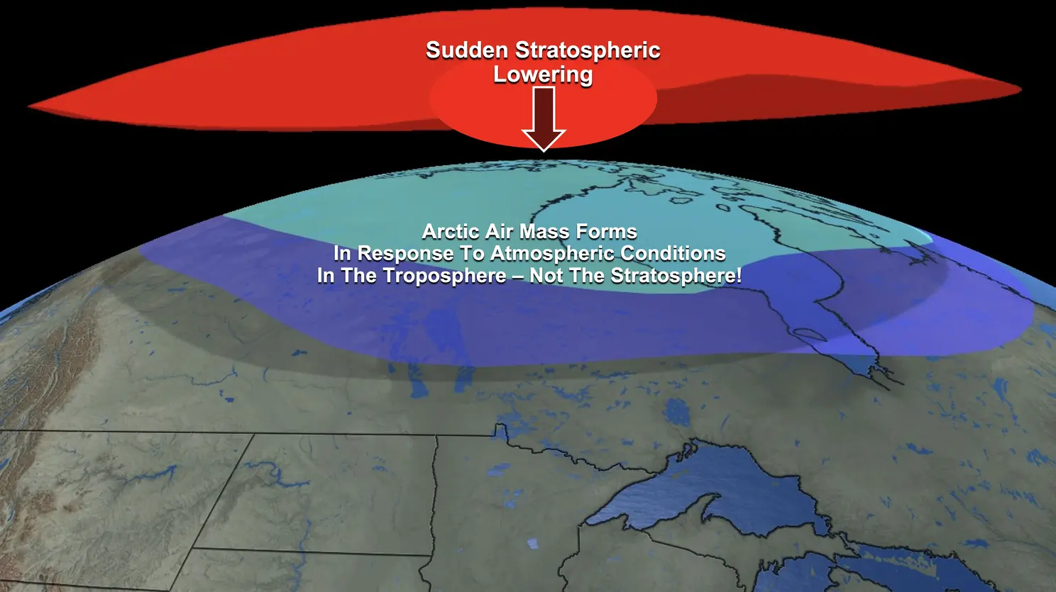
As the Arctic air mass expands and cools the troposphere, the atmospheric thickness decreases and the entire layer lowers. The stratosphere is pulled downward with it, creating adiabatic warming from compression and from warmer air aloft being displaced downward.
Any air that sinks warms by compression. This is elementary atmospheric physics.
So what looks like a “sudden warming” in the stratosphere is actually:
Sudden Stratospheric Lowering — a passive thermodynamic response to the Arctic air forming below.
Not a stratospheric cause. A tropospheric consequence.
Now, with that lengthy discussion about what is about to happen to our atmosphere, in layman’s terms, it means ARCTIC air is about ready to push out of Canada and into the lower 48. This will:
- Energize our storm track and produce “stormier” conditions for the northern/central plains AFTER Thanksgiving.
- Cold Arctic air with sub zero temps are a GOOD bet!!
Stay tuned…..